LOCAL NEWS
Severe thunderstorm watch issued for western Utah; flood watch in effect for SE Utah
Sep 21, 2022, 12:32 PM | Updated: 1:50 pm
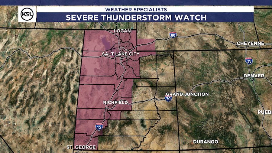
SALT LAKE CITY — A severe thunderstorm watch has been issued along the Interstate 15 corridor from Logan to St. George.
The watch lasts through 8 p.m. Wednesday and meteorologists will issue warnings as needed throughout the afternoon. Wind gusts over 58 mph and hail greater than 1″ are both possible with these storms.
Active warnings and flooding updates will be posted at the bottom of this article.
SEVERE THUNDERSTORM WATCH:
Here we go! This is in place now – 8PM this evening. The potential for damaging microburst winds and hail over 1" in stronger storms. #utwx pic.twitter.com/hj8DEZBMrG
— Matthew Johnson (@KSL_Matt) September 21, 2022
Meteorologists with the National Weather Service said there is an elevated risk of flooding in southeastern Utah while northern Utah could see severe thunderstorms. Flash flooding is expected at several national parks and southern Utah recreation areas.
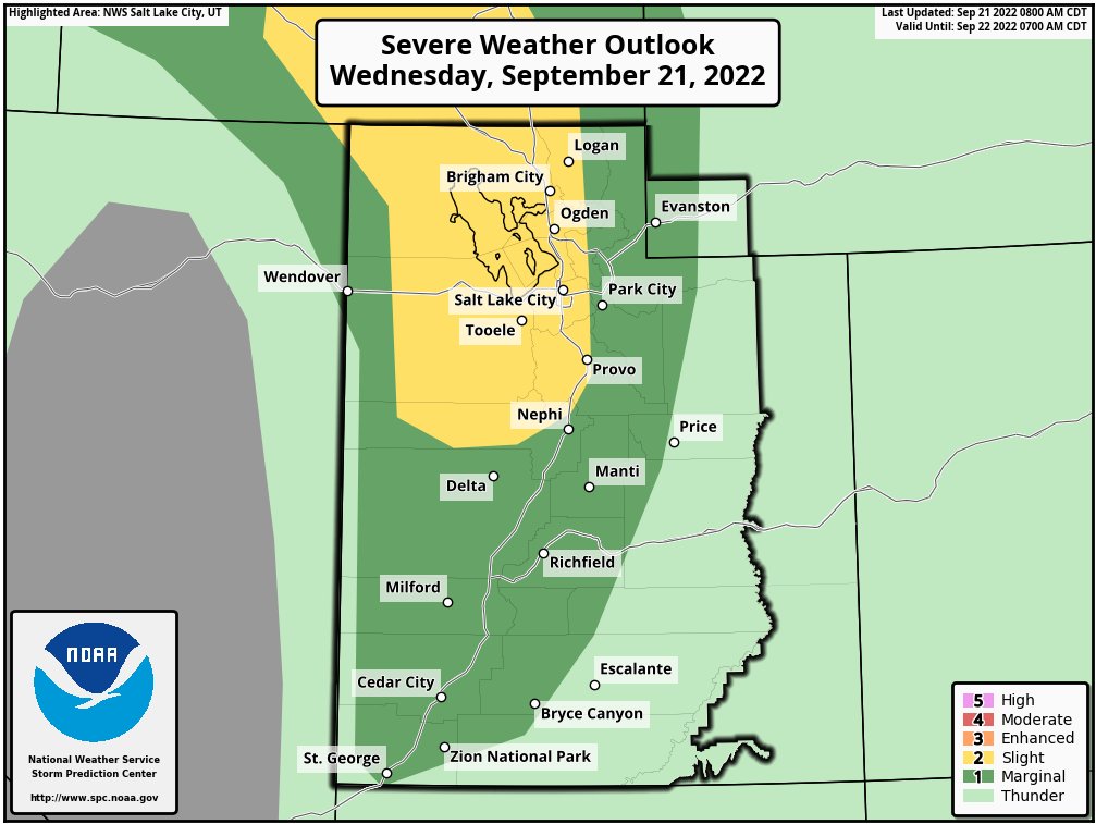
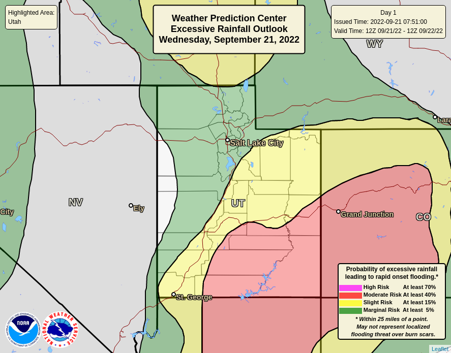
“Heavy rainfall is already underway across southern Utah and will spread northward through the day,” NWS meteorologists said.
There is a major risk for Flash Flooding across portions of the state today as storms are expected to produce very heavy rainfall. Slot canyons, normally dry washes, slickrock areas, and recently burned areas (burn scars) are of particular concern. Stay aware today! #utwx pic.twitter.com/lMhXTiZHXp
— NWS Salt Lake City (@NWSSaltLakeCity) September 21, 2022
UPDATES
1:50 p.m.
Severe Thunderstorm Warning including Provo UT, Orem UT and Spanish Fork UT until 2:15 PM MDT pic.twitter.com/Jm9VlqdWOJ
— NWS Salt Lake City (@NWSSaltLakeCity) September 21, 2022
1:30 p.m.
This storm will impact UT-12 between MM 33 and 57. Gusts up to 60 mph and quarter-sized hail are possible, in addition to heavy rainfall. #utwx https://t.co/pfZqie10HY
— NWS Salt Lake City (@NWSSaltLakeCity) September 21, 2022
1:12 p.m.
A severe thunderstorm warning has been issued for parts of the northern Wasatch Front as a line of storms is currently moving northeast into the area.
It will impact I-15, I-80, I-84 and U.S. Highway 89.
Severe Thunderstorm Warning including Brigham City UT, North Ogden UT and West Haven UT until 1:45 PM MDT pic.twitter.com/lHNNPsdZkt
— NWS Salt Lake City (@NWSSaltLakeCity) September 21, 2022
⚠Attention Wasatch Front: A line of storms is currently moving northeast into the Wasatch Front. This will impact portions of I-15, I-84, I-80, and US-89.
Wind gusts of 50-55 mph and nickel size hail are possible. #utwx https://t.co/zFfCxHIdX4
— NWS Salt Lake City (@NWSSaltLakeCity) September 21, 2022
1 p.m.
A special weather statement has been issued for Salt Lake City UT, West Valley City UT and West Jordan UT until 1:45 PM MDT pic.twitter.com/LnGcmcGwsG
— NWS Salt Lake City (@NWSSaltLakeCity) September 21, 2022
A special weather statement has been issued for Henrieville UT until 1:30 PM MDT pic.twitter.com/C2QyBRqMfi
— NWS Salt Lake City (@NWSSaltLakeCity) September 21, 2022
12:45 p.m.
Special weather statements have been issued through 1:15 p.m. for central Utah, along I-15. Heavy rain may lead to localized flooding and wind gusts could pass 50 mph.
This storm is expected to impact I-15 between MM 195 and 209. Heavy rainfall may lead to localized flooding. #utwx https://t.co/SGNJSEkS4W
— NWS Salt Lake City (@NWSSaltLakeCity) September 21, 2022
A special weather statement has been issued for Fillmore UT, Holden UT and Meadow UT until 1:15 PM MDT pic.twitter.com/RdgMYo0RZi
— NWS Salt Lake City (@NWSSaltLakeCity) September 21, 2022
12:30 p.m.
A severe thunderstorm warning has been issued for Nephi and parts of Juab County. It lasts until 1 p.m. Wednesday.
Severe Thunderstorm Warning including Nephi UT, Mona UT and Leamington UT until 1:00 PM MDT pic.twitter.com/tgwKYAdfse
— NWS Salt Lake City (@NWSSaltLakeCity) September 21, 2022
A special weather statement indicating strong wind gusts and possible hail has been issued for the Tooele Valley and western Salt Lake Valley through 1:15 p.m.
A special weather statement has been issued for West Valley City UT, Kearns UT and Tooele UT until 1:15 PM MDT pic.twitter.com/VWnh308FUj
— NWS Salt Lake City (@NWSSaltLakeCity) September 21, 2022
![[File] Utah Highway Patrol State Trooper car (Laura Seitz, Deseret News)...](https://staging.ksltv.com/wp-content/uploads/2022/12/UHP-State-Trooper-Car-file-121222.jpg)