WEATHER
LIVE UPDATES: Traffic, Weather Conditions As Winter Storm Warning Takes Effect
Nov 27, 2019, 5:14 AM | Updated: 12:42 pm
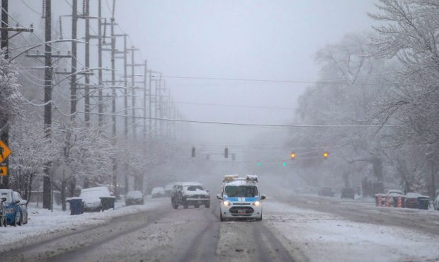
FILE: Cars navigate snow-covered streets on 800 South in Salt Lake City during a winter storm on Monday, Jan. 21, 2019. (Spenser Heaps, Deseret News)
(Spenser Heaps, Deseret News)

SALT LAKE CITY, Utah – The National Weather service has issued a winter storm warning for most of Utah, which will last through Saturday.
The storm is expected to drop between 5 – 10 inches on valley floors over the next few days, with a wave starting Wednesday morning.
This article will be continuously updated during the KSL TV’s team coverage throughout the morning. Refresh for the latest news.
11:15 a.m.
KSL news specialist was in Big Cottonwood Canyon, where snow and fog were causing some visibility issues. Road restrictions remain in place for both Big and Little Cottonwood Canyons.
Snow coming down pretty intensely right now I’ll be in Big Cottonwood Canyon! @KSL5TV #kslweather @kslnewsradio @UtahDOT pic.twitter.com/hQTJjwDLBk
— Jed Boal (@jedboal) November 27, 2019
10:50 a.m.
As the heavier snow begins to move southward, we’re seeing more crashes. UDOT is reporting two more in Weber County: In Roy, there’s a crash on the right shoulder of southbound Midland Drive at 4000 South. In Ogden, there’s a crash on the right shoulder of eastbound Wall Avenue at 20th Street.
There’s also a crash in Davis County, this one on the right shoulder of southbound I-15 at Center Street in Clearfield.
Roads in Box Elder, Cache, Weber and Morgan counties are seeing significant accumulation.
"Over the river & through the woods…" If you're on your way to #Grandma's house this #Thanksgiving, this is currently what your facing on #Utah roads in Box Elder, Cache, Weber & Morgan Counties. Brace yourself for winter driving cond's. @kslnewsradio pic.twitter.com/SnR0MiC8r3
— Rikki Meece (@KSLRikki) November 27, 2019
10:30 a.m.
In Weber County, there is a crash at North Street at Wall Avenue in Ogden, and a crash on northbound I-15 at the Riverdale offramp. In Salt Lake County, there’s a crash on eastbound I-215 at 2200 West in Taylorsville, and a crash on southbound I-15 at 3600 South in South Salt Lake. In Wasatch County, there’s a crash on eastbound US 189 at mile post a8 near Deer Creek Reservoir.
Col. Michael Rapich tweeted that seven troopers’ vehicles have been hit so far today.
Seven Troopers cars struck so far while helping motorists!! Thank you to KSL and the Dave and Dujanovic show for taking time to share the Slow Down and Move Over message this morning as we prepare for another major winter storm on our busiest travel day of the year. https://t.co/pCJ3hPBzI4
— Michael Rapich (@ColonelRapich) November 27, 2019
9:50 a.m.
The Utah Highway Patrol tweeted that a trooper’s vehicle had been hit by a car in Summit County: “Fortunately, he wasn’t in it at the time.”
Trp. Strong's vehicle was just hit in Summit County. Fortunately, he wasn't in it at the time.
Our thanks goes out to @kslnewsradio and @D2KSL for helping us get @ColonelRapich's and UHP's message out on this issue. 🙏🏼
Please slow way way down when approaching flashing lights! pic.twitter.com/1N2jeCnD0j
— Utah Highway Patrol (@UTHighwayPatrol) November 27, 2019
UDOT also reported another crash in Weber County, this one on the right shoulder of southbound Harrison Boulevard at 12th Street.
9:35 a.m.
The National Weather Service tweeted information about the storm, which stalled north and west of the Wasatch Front.
“If you were hoping to wake up to a winter wonderland across the Wasatch Front this morning, you probably have several more hours to wait,” according to the NWS.
Where's the snow? If you were hoping to wake up to a winter wonderland across the Wasatch Front this morning, you probably have several more hours to wait. #utwx #utsnow pic.twitter.com/NZkmPBVw5V
— NWS Salt Lake City (@NWSSaltLakeCity) November 27, 2019
9:30 a.m.
UDOT is reporting more crashes in Weber County. On northbound I-15, a crash at the 2700 North onramp (mile post 349) has the left lane closed. A crash on SR 39 about two miles east of Ogden is affecting both directions.
KSL news specialist Felicia Martinez is reporting from Mobile 5. She’s currently in Parley’s Canyon.
Remember when I said Parley’s Canyon is looking good? It’s now snowing, but we’ve got snow plows hard at work! @KSL5TV pic.twitter.com/KynfWnouVb
— Felicia Martinez (@FeliciaKSL) November 27, 2019
9:15 a.m.
The Ogden area started to see the effects of the winter storm, with snow accumulating on busy roads. UDOT reports a crash on westbound 12th Street at Harrison Boulevard. The crash was affecting the right shoulder.
LIVE: Ogden is getting some of that snow storm right now. This is a look at 12th Street right now.
Posted by KSL 5 TV on Wednesday, November 27, 2019
Snow starting to stick in ROY and other areas up north of SLC. pic.twitter.com/AdfGTg5Iwk
— Grant Weyman (@KSLweyman) November 27, 2019
Here's the mouth of Weber along US89. It's becoming a mess here. pic.twitter.com/KviLm0U7nY
— Grant Weyman (@KSLweyman) November 27, 2019
A crash was reported in Iron County on southbound I-15 about two south of Cedar City.
8:55 a.m.
KSL meteorologist Grant Weyman noted the higher elevations have been more affected by the first wave of the winter storm, sharing a photo of Weber Canyon on Twitter.
The snow has certainly been more of an issue in the high elevations this morning. Look at Weber Canyon…. snow on the roads. pic.twitter.com/3PISPNeoQ3
— Grant Weyman (@KSLweyman) November 27, 2019
For a look at what’s to come, KSL news specialist Ladd Egan shared a video of the winter storm making its way to Utah.
VIDEO: This is the #WinterStorm that’s headed to #Utah
This is from Sierra Co. #California where I-80 was shut down in both directions because of crashes amid blizzard conditions. @KSLweyman tells us to be prepared for wind and BIG snow totals by Saturday @KSL5TV @kslnewsradio pic.twitter.com/iFlZEFTTgP
— Ladd Egan (@laddegan) November 27, 2019
8:30 a.m.
Ahead of expected storms, Gov. Gary Herbert took to Twitter to remind Utahns to “please buckle up, slow down, and increase your following distance.”
Much of Utah is under a winter storm warning, with heavy snow expected. If you are driving today, please buckle up, slow down, and increase your following distance. Plan for extreme driving conditions.
— Gov. Gary Herbert (@GovHerbert) November 27, 2019
UDOT reports a crash on westbound US 40 at mile post 3, just north of SR-248, in Park City. The right shoulder is closed, and it’s expected to be cleared by 9:30 a.m.
8:15 a.m.
Road restrictions have been put in place for Big and Little Cottonwood Canyons. Chains or four-wheel drive are required.
UDOT has also reported several new crashes.
In Wasatch County, there’s a crash on US 189 at mile post 17, near Lower Deer Creek. In Weber County, there’s a crash on westbound I-84 at the Riverdale Road onramp (mile post 82).8 a.m.
Winds combined with icy and snowy roads are making for a precarious commute in Summit County. Despite the conditions, though, UDOT has only reported on crash in the county so far this morning.
LIVE: Summit County continues to be hit hard by today's storm. You can see how windy it is. In addition, roads are snowy and icy across the county.
Posted by KSL 5 TV on Wednesday, November 27, 2019
7:30 a.m.
KSL Meteorologist Grant Weyman says the three-day storm will be happening in waves, with snow off and on throughout areas of Utah. By the end of the three-day storm warning, snow totals could be between 5 – 10 inches on the valley floors.
“It’s not all coming in at once,” he said.
Summit County continues to be hit hardest by that first wave, with snowy and slushy roads throughout the county.
A #KSLTrafficTrooper lets us know there is ice underneath the snow around Park City. He says he fishtailed with brand new snow tires at Kimball Jct. pic.twitter.com/GSjy8QSj2U
— Heather Kelly (@KSLHeatherKelly) November 27, 2019
In Emery County, UDOT has reported another crash on SR 31. This one is at mile post 46, about one mile west of Huntington. It’s expected to be cleared by 8:30 a.m.
7:10 a.m.
UDOT reports a crash on SR 10 at mile post 55, about 7 miles north of Huntington, in Emery County.
6:45 a.m.
UDOT is reporting debris in the road on northbound I-15 at 400 South in Springville (mile post 260). The HOV lane is blocked, and authorities expect it to be cleared by 7:30 a.m.
There is also a crash on westbound I-80 at mile post 155 in Summit County. It’s expected to be cleared by 8 a.m.
6:15 a.m.
UDOT is reporting that SR-143 past Brian Head to Mammoth Springs is closed due to road weather. The closure affects both directions between mile post 17 and mile post 28.
In Wyoming, US-191 is also closed in both directions between I-10 and the Utah-Wyoming state line.
“Motorists are advised to plan travel, expect delays, and use alternate routes where possible,” according to UDOT.
There is also a crash on the northbound I-15 at 14600 South offramp in Draper. The left shoulder is closed. Authorities estimate the scene will be cleared at 7:15 a.m.
If you’re traveling for the holiday, make sure your vehicle has tires that appropriate for the conditions.
Have snow tires, chains and emergency supplies in your car if you are heading to grandma's house today: https://t.co/a0QF70HzRQ
— KSL Traffic Center (@KSLTraffic) November 27, 2019
6 a.m.
UDOT is reporting a crash on Midland Drive at Hinckley Drive in West Haven in Weber County. The scene is expected to be cleared by 7 a.m.
5:45 a.m.
Summit County is getting hit hard with snow and wind this morning. UDOT cameras show nearly-horizontal snowfall as the wind blows. KSL Newsradio’s Heather Kelly says roads are covered with snow throughout the county as well as the Mountain View Corridor in West Valley.
Sideways snow in Park City and Deer Valley. Snow covered roads through Summit County as well as on Mountain View Corridor in West Valley. pic.twitter.com/XWjvqeqhlp
— Heather Kelly (@KSLHeatherKelly) November 27, 2019
Roads are wet this morning! If you have plans to travel today ahead of Thanksgiving @UtahDOT says the earlier the better. @KSL5TV pic.twitter.com/sPVEL6OvL6
— Felicia Martinez (@FeliciaKSL) November 27, 2019
5:30 a.m.
KSL meteorologist Grant Weyman says valley snow will be coming and going throughout the morning, but higher-elevation areas will see the brunt of the morning storm. He also warns that drivers should be aware of wind gusts up to 45 miles per hour in areas.
Look at Park City this morning! Blowing snow and the roads are covered! pic.twitter.com/wyEkaKQhd1
— Grant Weyman (@KSLweyman) November 27, 2019
5 a.m.
In addition to expected snow, morning commuters will have to deal with wind gusts. KSL meteorologist Grant Weyman said there have been some gusts up to 45 miles per hour. Commuters are urged to leave early this morning so they can drive slowly to account for wind and snow.
It's WINDY with the south winds! Some gusts up to 45mph already! Here are some other recent winds. pic.twitter.com/VVYAlGYoxA
— Grant Weyman (@KSLweyman) November 27, 2019